Showing posts with label Michigan. Show all posts

September 02, 2010

UP north

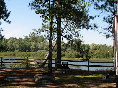
The Ojibwa Indians made the Grand Island area their permanent home. They called the seven mile long Grand Island Gitchee Minis or "Great Island." In winter they moved across the harbor to Minis-ing on the mainland, the "Place of the Great Island." From the dining table we look across to Great Island.

We spent four fun-filled days camped at the Bay Furnace campground in Hiawatha National Forest in Christmas, Michigan. The campground got it's name from the blast furnace that is nearby where pig iron was made between 1870 and 1877.

We have really experienced the UP. We have tasted pasties, made with either beef, pork, or vegetables in a pastry crust. The copper miners would take them for their lunches.


We have seen all sorts of trees, especially the beautiful white birches, and even burned a few in our fires.

On the 5th day the high is forecast to be 61 and the low is forecast to be 48. The winds will shift to the northwest and gust up to 50 mph. Waves will build Friday evening up to 20 feet, which will cause beach erosion and some minor flooding. It is beginning to feel a little too much like Christmas. Time to move a little further south...at least to Wisconsin.


Christmas, Mi

Yesterday it was waterfalls so today we chose range lights. These are pairs of lights that were used to guide the ships into the harbor. They would line up the first light with the light on the second one to navigate the channel. This is the Grand Island Harbor front range light near the shore, also known as the Christmas Light with the rear light in the background. The 62 foot tall rear light was built in 1915 and was visible for 16 miles. It was abandoned and sold by the coast guard to the forest service.

Now there just happened to be a geocache at both lights so I had to stop to sign the log on a log!

"Powers of the Air," was a young Ojibwa hero named Ogichidaa who followed his fallen father as the leader of the Grand Island band of his people. His tales of ancient legends, told to and recorded by Henry Rowe Schoolcraft, became the basis for the "Song of Hiawatha." The petroglyph was carved in 1820 by a French trapper and guide.

It was a beautiful morning even though it was beginning to get cloudy.

Quite often there are streams of water that flow into the lake, some larger than others.

Across the highway is Scott Falls. Yes, that is Leon behind it.

We passed this fixer upper in Au Train, small village west of Christmas.

We were on the way to Brownstone Inn, which had already been fixed up! A retired Detroit policeman built the inn in the 1940s. It had been left in disrepair when the current owners purchased it. The outside was made with rocks the policeman hauled from the lake. Inside the wainscotting is mahogany with chairs made locally. Quite a charming place.

There were several cabins on either side which had not been restored.

We drove back into Munising to visit another rear range light. The Grand Island Harbor (Munising) Light is a 33 foot conical steel tower built in 1908.

Beside it was a cute old house typical of many in town.

The Munising front range light is on the shore about 2 blocks in front of the rear one. It is now an active lighthouse.

Then the rain caught up with us and it was time to explore the casino and I did win $45.

September 01, 2010

Munising, Michigan

Today we visited the Pictured Rocks National Lakeshore by land. This was the first national lakeshore authorized in 1966. It is six miles across at its widest point and hugs Lake Superior's shoreline for over 40 miles. After a heavy rain in the night we thought it would be the perfect day to visit some of the eleven waterfalls in Alger County. This little woodpecker was oblivious to our hike down the trail.

Then we passed blue berries that I had to sample. Not ripe!  Hmmm..not sure what these are!

The 1.2 mile hike was well worth it to view Miners Falls with its 50 foot cascade.

A couple miles down the road was a shorter walk to visit Munising Falls. It also has a 50 foot drop.

Munising Coast Guard Station on Sand Point is currently the national park headquarters but will soon be renovated as it was when it was used from 1933 until it closed in 1960.

At one time they had four boats but only participated in the rescue two large vessels.

This area is quite noted for the shipwrecks that lie in the harbor. There is even a glass bottom boat tour that you can take to view them.

Wagner Falls is in the town of Munising and has a 20' cascade. The Ojibwa Indian words "Kitchi Minissing" means "place of the island," which lies in the bay offshore.

Also nearby we visited Alger Falls which is on the side of the highway.

The area had a vast lumbering industry and evidently there is still a lot of logging.

This fellow decided to go closer for a better picture of Alger Falls.

And the perfect ending to a great day.

August 30, 2010

Pictured Rocks, MI

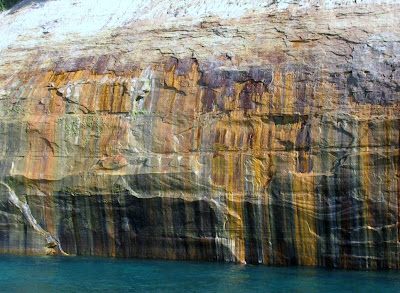
In the small town of Munising we visited the Pictured Rocks National Lakeshore. Their claim to fame here are the rocks that have been colored, or discolored, by the minerals in the ground water. The cliffs rise to 200 feet above the lake. About the only way to see them is a three hour boat ride. All aboard!!!


Did I mention we are having a warm spell. It was about 93 when we departed. And of course I sat on the top deck in the sun to have the best seat! We went out into Lake Superior on our 34 mile boat ride and passed miles of rocks, interpersed with sandy beaches.


Some of the cliffs are those in Longfellow's "The Song of Hiawatha."


We spotted this cove in the shade and I was so excited when our captain manuevered the boat into it!


All of the rock sculptures have names. This one near the end is called Chapel Rock.


Everything seemed to appear differently as we returned to shore and the sun shone at a different angle.


We passed two waterfalls but only this one had any running water.

The East light house is on the banks of Grand Island. There are several homes on the island, which now is part of the Hiawatha National Forest. The name Munising comes from the Chippewa word for grand island.

August 29, 2010

Tahquamenon Falls, Michigan

Tahquamenon Falls are a really popular spot in the UP. So we joined the Sunday afternoon crowds for a look. First we stopped at a the lower falls, a series of rapids and cascades flowing around an island.

There was a pretty good rush of water flowing from the opposite side of a little island.

I was excited to see this ruffled grouse in the tree alongside the boardwalk.

And where there is one grouse, I guess there is usually another.

The discoloration, obvious in the upper falls, is caused by tannic acid in the water from the cedars and hemlocks upstream. The upper falls are nearly 50 feet high and 200 feet wide.

It was a hot day to be hiking to waterfalls but the serene setting we found alongside the Tahquamenon River at the Rivermouth state park campground was idyllic. It was just like being in Paradise. Oh, we were. Paradise, Michigan.

We saw lots of folks paddling up and down the peaceful river. And where is my kayak?! ... in Arkansas! Also, there were several small motorized boats. Folks were catching muskie, walleye, northern pike, etc.

Sault Ste. Marie, Michigan

I have never had a visual of what the Soo Locks look like and have always heard of Sault Ste. Marie. Well now I have that picture. Sunday morning was a perfect time to traipse around town while folks were at church.

We toured the Corps of Engineers Visitors' Center and then went up the platform to view the closest lock. The first American lock had been built in 1855. Sailors and travelers referred to the town as the Soo.

There is a drop of 21 feet from Lake Superior to Lake Huronon the St. Mary's River. Four locks on the American side bypass this barrier. We chose not to hang around an hour waiting for the boat scheduled to come through at 2:30.

This was not the view we saw as we chose not to drive all around pulling the trailer (thanks to a large photograph inside the visitors' center).

There is a lot of security around the gated park as you approach the Soo Locks. Hmmm.

Sault Ste.Marie is a small town with a population of only 16,000. I picked up the Scales of Justice geocache on the courthouse lawn.

Still don't know what this small tree is. Anyone?