Showing posts with label Arkansas. Show all posts

May 01, 2012

Eureka !

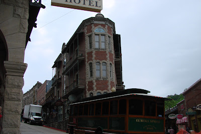
Eureka Springs, not far south of Missouri in northwest Arkansas, is such a quaint, eclectic, and fun city to visit.  Victorian homes dot the countryside mixed among handsome stonework of the springs and buildings. It became a hippy community in the 1960s and evolved into a popular area for artists and artisans to settle. Still the population of this town nestled in the Ozark Mountains is only a little over 2,000. It is a major tourist destination in Arkansas so we made a day trip up from Beaver Lake.

Our first stop was Thorncrown Chapel designed by Fay Jones in 1980, which lies outside the historic district.


Eureka Springs became famous for the springs in the area that would cure ailments in days of old.


We got into town early and strolled the streets and trails throughout town before stopping at the Crescent Hotel at the "top of the hill." All in the historic district seems quaint and old and steep and peaceful. 


April 30, 2012

Crystal Bridges

One of many reasons for our visit to northwest Arkansas was to visit Crystal Bridges. This new museum of American art in Bentonville is first class and well-worth a visit. We met Will there and all enjoyed the art, the architecture, and the outdoor trails that wind among the gardens.


Norman Rockwell's Rosie the Riveter is quite popular. The art is arranged in chronological order from colonial times to contemporary.


This was day one of a new trial for the floating dock that would support the window washers while they cleaned the many windows. It was working nicely.


An overview shows how water is incorporated into the setting. It amazes me that a bicycle trail begins one block from the square and how much land (120 acres) was involved in building this.  Alice Walton,  daughter of Sam, has made it all happen.


The dogwoods, azaleas, and many other plants adorned the woodland setting.


Both inside and out you will find sculptures such as this silver tree at the entrance.


I love the humorous signs found in the parking garage such as this one and then you will find Pinocchio inside. 


Even if you can't make it to the museum where your entrance fee is sponsored by Walmart, do go visit the website and see to what you have to look forward.

It seemed logical to go to the square in Bentonville afterwards where we toured the Bentonville 5 and dime store, now a museum, on the town square. It is one of the cleanest town squares I have seen so we even sat on the park bench and visited while I gave my feet a quick refresher in the fountain. Afterall, it is Arkansas.


Pea Ridge and War Eagle

It amazed me there are so many places that I have never been so close to home. We stopped at nearby Pea Ridge Battlefield and enjoyed a tour of the small museum and then a drive around the seven mile trail. 


We stopped and visited with a quite knowledgable volunteer at the reconstructed Elkhorn Tavern along the trail. He explained how this battlefield did not have trees but was an area covered in grasses on which pea vines grew.  Most interesting to us was the 97 year old man we met the next day in the Walmart parking lot in Rogers, who asked us directions to Pea Ridge. He had come from Okalahoma to see where his grandfather fought in the Civil War.


From Pea Ridge we went to see where so many people go annually for an arts and crafts festival at War Eagle. I had no idea where it was even located and just had to see the place. I do like an old gristmill and was also looking forward to some freshly ground products. We found it all! It is amazing that this mill was built in 1832 in this valley alongside War Eagle Creek.


The bridge adjacent to the mill is over one hundred years old. It seems we see fewer and fewer of these old bridges. Wooden planks provide a safe crossing over War Eagle Creek.


I bought my corn meal, whole wheat flour, bulgar, biscuit mix, etc without having to contend with crowds and we were off back up the winding roads across the mountainside.

Beaver Lake

While we were camping at Crystal Springs it dawned on us that we were 20 miles closer to northwest Arkansas than if we were at home, so we decided to take off and travel west for some more camping. Site 6 at Lost Bridge north was a perfect spot for us and available!  What a nice view of Beaver Lake.


While geocaching on a nearby hill we were provided a fantastic view of Beaver Lake


Before long we were off down a winding country road to visit our friends Becky and Ed. Becky greeted us from the deck. 


It was a treat to see her beautiful flowers blooming profuesly on "the Property." What a fantastic home they have and we are so glad they now live in Arkansas! We spent many hours visiting and had weigh too many meals with them but enjoyed every second of it!


Back at the lake I enjoyed watch this heron near our campground. He would stretch his neck as he called for some company! 


We did make a trip to Fayetteville to visit with Will. He shared a leaf from the nearby tree so Leon could feed the goat. Needless to say Niles the dog wanted some leaves also.


We did not have so many fires at Beaver Lake as the evening had warmed considerably but we did have a few for roasting marshmallows. Is that a look of excitement. They go great with chocolate covered mint cookies!


Yes, we will return to Lost Bridge and hope to get this same spot. It was named for the bridge that was built nearby to cross the White River before the lake was built. The county on the opposite side of the river chose not to connect a road to the bridge and it became known as the lost cause bridge. Or so the story goes. This was certainly no lost cause for us.


May 10, 2011

Russellville, Arkansas

Alongside the banks of the Arkansas River was once the site of the Western Cherokee Nation. The Indians settled in this valley in the late 1700s. A group of Cherokee left western North Carolina to escape the encroachment of the Europeans. Now the lock and dam facilitates traffic on the river. The only smoke signals in the area now arise from the nuclear power plant in the background.
The Corps of Engineers campground on Old Post Road suited us fine for a weekend. Just 1 1/2 hours from home and we were camping again!

We had a peaceful spot high on the banks of the Arkansas River.
The locks can be seen on the right side of the dam. This was also the area of a bustling riverport town, Norristown, an early settlement along the old post road. The mail crossed the river here by ferry until the late 1800s when the longest pontoon bridge to cross moving water was built. It did wash out four times in it's 30 years of service.

Our reason to be here was the Russellville geocaching event being held at the day use portion of the park. Here we all looked for a cache on the bleachers at the ball field.
Sometimes it takes a taller person to help retrieve a cache.

After a morning of caching we enjoyed a fine potluck with hot dogs and hamburgers.

A little geocaching around Russellville on Sunday morning led us to this "London calling" cache. I thought if anyone was watching (a muggle) that I would make them think I was just making a phone call.
On the way home we made the steep winding ascent up Mt. Nebo.
What a view from every side. This is the Arkansas River and Lake Dardanelle below.

The 375 Step cache led us down this path. We did not count the steps. It took all the energy just to get up them! There are several interesting hiking trails on Mt. Nebo.
And we thought the road from Hot Springs to Russellville had some serious curves.
They were really releasing some water from Lake Nimrod, further south towards Hot Springs, where we stopped to see all the water flowing down the Fourche La Fave River.