August 30, 2010

Pictured Rocks, MI

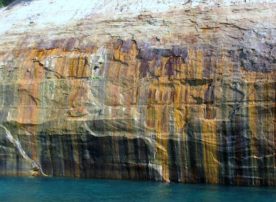
In the small town of Munising we visited the Pictured Rocks National Lakeshore. Their claim to fame here are the rocks that have been colored, or discolored, by the minerals in the ground water. The cliffs rise to 200 feet above the lake. About the only way to see them is a three hour boat ride. All aboard!!!


Did I mention we are having a warm spell. It was about 93 when we departed. And of course I sat on the top deck in the sun to have the best seat! We went out into Lake Superior on our 34 mile boat ride and passed miles of rocks, interpersed with sandy beaches.


Some of the cliffs are those in Longfellow's "The Song of Hiawatha."


We spotted this cove in the shade and I was so excited when our captain manuevered the boat into it!


All of the rock sculptures have names. This one near the end is called Chapel Rock.


Everything seemed to appear differently as we returned to shore and the sun shone at a different angle.


We passed two waterfalls but only this one had any running water.

The East light house is on the banks of Grand Island. There are several homes on the island, which now is part of the Hiawatha National Forest. The name Munising comes from the Chippewa word for grand island.

August 29, 2010

Tahquamenon Falls, Michigan

Tahquamenon Falls are a really popular spot in the UP. So we joined the Sunday afternoon crowds for a look. First we stopped at a the lower falls, a series of rapids and cascades flowing around an island.

There was a pretty good rush of water flowing from the opposite side of a little island.

I was excited to see this ruffled grouse in the tree alongside the boardwalk.

And where there is one grouse, I guess there is usually another.

The discoloration, obvious in the upper falls, is caused by tannic acid in the water from the cedars and hemlocks upstream. The upper falls are nearly 50 feet high and 200 feet wide.

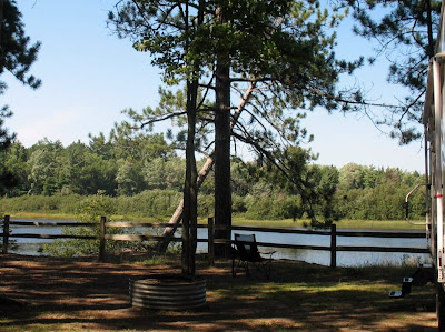
It was a hot day to be hiking to waterfalls but the serene setting we found alongside the Tahquamenon River at the Rivermouth state park campground was idyllic. It was just like being in Paradise. Oh, we were. Paradise, Michigan.

We saw lots of folks paddling up and down the peaceful river. And where is my kayak?! ... in Arkansas! Also, there were several small motorized boats. Folks were catching muskie, walleye, northern pike, etc.

Sault Ste. Marie, Michigan

I have never had a visual of what the Soo Locks look like and have always heard of Sault Ste. Marie. Well now I have that picture. Sunday morning was a perfect time to traipse around town while folks were at church.

We toured the Corps of Engineers Visitors' Center and then went up the platform to view the closest lock. The first American lock had been built in 1855. Sailors and travelers referred to the town as the Soo.

There is a drop of 21 feet from Lake Superior to Lake Huronon the St. Mary's River. Four locks on the American side bypass this barrier. We chose not to hang around an hour waiting for the boat scheduled to come through at 2:30.

This was not the view we saw as we chose not to drive all around pulling the trailer (thanks to a large photograph inside the visitors' center).

There is a lot of security around the gated park as you approach the Soo Locks. Hmmm.

Sault Ste.Marie is a small town with a population of only 16,000. I picked up the Scales of Justice geocache on the courthouse lawn.

Still don't know what this small tree is. Anyone?

August 28, 2010

Powwow in St. Ignace, Michigan

We went to the opening ceremony of a joint rendezvous and powwow. The rendezvous consists of people dressed in period costume and camping as the fur trapper and Indians would have during the fur trading days. We did not see any other people for the rendezvous.

Tents were set up around the park selling items that would have been traded in a much earlier time. They included furs, beads, dream catchers, and mocassins; as well as current Indian crafts.

The flag ceremony began the pow-wow. I do enjoy hearing the drums and singing.


August 27, 2010

Mackinac Island, Michigan

While strolling the boardwalk we watched the three ferry lines transport people back and forth between St. Ignace and Mackinac Island.


We chose the catamaran for our adventure to the island.


Since there are no cars on the island everything is done using horses or bicycles.


The Grand Hotel is an extravagant place and probably the best known location on the island. It sits towards the top of the bluff overlooking Lake Huron.


Along the shoreline the road is flat that circles the island. We went on a Friday and I would imagine on the weekend it is next to impossible to find a parking place for your bicycle.


There are large homes on the island. Most seem to have a turret including the new homes being built.


Many of them are used for bed and breakfasts such as the Harbor View.


"We biked it, we liked it!!" The 8 mile path leads around the entire island and is quite flat and lovely. On the back side of the island there are no shops; just the seashore and a constant breeze.


On the island you can rent a horse, or a horse and buggy, or ride the sightseeing wagons. That could make for quite a mess if these guys weren't constantly scooping!


Everyone seemed to be having fun. We were relieved to finish our 8 mile ride since we had probably already ridden three.


We initially took off looking for the Iriquoy for lunch but I got my Indians mixed up! Without checking my notes I spotted Algonguin Street on the map and assumed the restaurant was in that location. So off we rode up the hill and down Annex Road. We finally met a lady who had lived on the island for fifty years and informed us there was no Algonquin Restaurant! She suggested we ride on down Annex Road to the Stonecliff Restaurant. Here we saw some of the wooded area of the island on top of the bluff which was good because the Stonecliff wasn't open for lunch. We finally made it back down the hill and located a restaurant 90 minutes and several miles later. So much for relying on my memory and not my notes!!! Coming back into town we were greeted by lots of balloons floating overhead.


Quite a nice neighborhood along the shoreline.


Everyone is bustling down along the docks. There are plenty of shops, restaurants, and tourists.


Horses are lined up near the ferry docks waiting for more tourists.


The horses and pedestrians do have the right of way but I am not sure everyone knows that.


We arrived back at the docks where this driver was waiting to unload something while others waited to load themselves and their bikes onto the ferry.

I just knew exactly how this guy felt! But what a glorious day it was. Yes, we saw the Arch Rock but no, we did not climb the steps. No, we did not go back up the hill and tour the fort. Maybe next time.

August 26, 2010

St. Ignace, Michigan

At last we are in the UP (upper peninsula) of Michigan!  Imagine! A two day trip took two weeks. St.Ignace was created in 1671 and is the second oldest continuously inhabited city in Michigan. Explorers Marquette and LaSalle led the French to this area and fur trading brought the French and Indians together. We found our choice of spots at the Moose Lodge.

Soon we were set up and ready to explore the area.

At the visitor's center Leon was surprised to find this old telephone equipment which took him back to his working days. The operators were not replaced in St. Ignace until the mid 1970s.

We enjoyed walking alongside the marina and Lake Huron on the boardwalk provided.

It is hard to believe that these poles marking the fire hydrants in case of snow are this tall!

In the mid 1800's commercial fishing grew to become more important than fur trading. The mackinaw boat was a common sight in the lakes.

As we finished the walking tour we spotted Rich Eddys playing some oldie rock music at the marina.

The Mackinac Bridge crosses the straits from Mackinaw City to St. Ignace, a distance of five miles, where Lakes Michigan and Huron merge. We caught this view from one of several drives into the Straits State Park. Our Michigan parks pass has been a wise choice. We can even go to any of the state parks and use the "sanitation station" aka rv dump!

The bridge was opened in 1957 and replaced the car ferries. On Labor Day we will avoid the crowds that come for the well publicized bridge walk by going further north!